


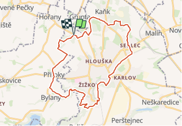

12.3 km | 15.8 km-effort
![Trail On foot Kutná Hora - [Ž] okruh kolem Kutné Hory - Photo](https://media.geolcdn.com/t/1900/400/aa3389e9-252d-4a2e-b82d-4342d9e74c81.jpeg&format=pjpeg&maxdim=2)

Tous les sentiers balisés d’Europe GUIDE+


FREE GPS app for hiking
 SityTrail
IGN / Geographical institutes
SityTrail World
The world is yours!
Trail On foot of 17.9 km to be discovered at Central Bohemia, Unknown, Kutná Hora. This trail is proposed by SityTrail - itinéraires balisés pédestres.
Trail created by cz:KČT.
![Trail On foot Kutná Hora - [Ž] okruh kolem Kutné Hory - Photo 1](https://media.geolcdn.com/t/2048/auto/8236db02-837c-4950-b115-a9f2d264682d.jpeg&format=jpg&maxdim=0 "Trail On foot Kutná Hora - [Ž] okruh kolem Kutné Hory - Photo 1")
![Trail On foot Kutná Hora - [Ž] okruh kolem Kutné Hory - Photo 2](https://media.geolcdn.com/t/2048/auto/2392d771-9e11-402d-b86b-30da97e2c6b0.jpeg&format=jpg&maxdim=0 "Trail On foot Kutná Hora - [Ž] okruh kolem Kutné Hory - Photo 2")
![Trail On foot Kutná Hora - [Ž] okruh kolem Kutné Hory - Photo 3](https://media.geolcdn.com/t/2048/auto/356da5ef-325d-4151-b800-a70afecab442.jpeg&format=jpg&maxdim=0 "Trail On foot Kutná Hora - [Ž] okruh kolem Kutné Hory - Photo 3")
![Trail On foot Kutná Hora - [Ž] okruh kolem Kutné Hory - Photo 4](https://media.geolcdn.com/t/2048/auto/80432716-7978-4159-a8f4-72a7d5d2af42.jpeg&format=jpg&maxdim=0 "Trail On foot Kutná Hora - [Ž] okruh kolem Kutné Hory - Photo 4")
![Trail On foot Kutná Hora - [Ž] okruh kolem Kutné Hory - Photo 5](https://media.geolcdn.com/t/2048/auto/b3f4bf04-8d56-4777-a172-f115080357b3.jpeg&format=jpg&maxdim=0 "Trail On foot Kutná Hora - [Ž] okruh kolem Kutné Hory - Photo 5")
![Trail On foot Kutná Hora - [Ž] okruh kolem Kutné Hory - Photo 6](https://media.geolcdn.com/t/2048/auto/37512e50-bd86-4ddd-88ed-571910b4e303.jpeg&format=jpg&maxdim=0 "Trail On foot Kutná Hora - [Ž] okruh kolem Kutné Hory - Photo 6")
![Trail On foot Kutná Hora - [Ž] okruh kolem Kutné Hory - Photo 7](https://media.geolcdn.com/t/2048/auto/0a692b79-178b-46f5-8e19-2376fda89e33.jpeg&format=jpg&maxdim=0 "Trail On foot Kutná Hora - [Ž] okruh kolem Kutné Hory - Photo 7")
![Trail On foot Kutná Hora - [Ž] okruh kolem Kutné Hory - Photo 8](https://media.geolcdn.com/t/2048/auto/d201ceac-355c-4d78-ae6e-5693a51c0eb8.jpeg&format=jpg&maxdim=0 "Trail On foot Kutná Hora - [Ž] okruh kolem Kutné Hory - Photo 8")
![Trail On foot Kutná Hora - [Ž] okruh kolem Kutné Hory - Photo 9](https://media.geolcdn.com/t/2048/auto/42599403-d7d2-4563-b546-65a0323e5ff3.jpeg&format=jpg&maxdim=0 "Trail On foot Kutná Hora - [Ž] okruh kolem Kutné Hory - Photo 9")
![Trail On foot Kutná Hora - [Ž] okruh kolem Kutné Hory - Photo 10](https://media.geolcdn.com/t/2048/auto/aa3389e9-252d-4a2e-b82d-4342d9e74c81.jpeg&format=jpg&maxdim=0 "Trail On foot Kutná Hora - [Ž] okruh kolem Kutné Hory - Photo 10")
On foot
![Trail On foot Starý Kolín - [M] Starý Kolín - Kutná Hora - Photo](https://media.geolcdn.com/t/375/260/56aad995-e15c-4f50-b766-a9a56ed9df21.jpeg&format=jpg&maxdim=2)
On foot